The history of Hassocks
This page contains links to external sites. Hassocks Parish Council is not responsible for the content or accuracy of such sites.
Hassocks History
Keymer & Clayton War Memorials
To read the story of every man on Keymer and Clayton War Memorials please click the link below:
https://keymerclaytonwarmemorials.wordpress.com/
Hassocks contains the old parishes of Clayton (meaning settlement or farmstead on the clay) and Keymer (cow’s mere), describing lush meadowland.
Currently the home of about 7,000 people, the village’s roots stretch back far into prehistory, testified to by the discovery of Neolithic clay spoons and Stone Age flint tools in the area. Bronze Age settlers also set up home in the area some 4,000 years ago, followed by the Romans nearly 2,000 years later.
It is thought that metal workers visited the area at the start of the Bronze Age in about 600 BC. The remains of a Bronze Age fort can be seen at the top of nearby Wolstonbury Hill.
Artefacts and remains from Stone Age, Neolithic, Bronze Age, Iron Age, Roman and Anglo-Saxon times have been found in the area, including evidence of a Roman road leading towards a settlement at Stonepound. An Anglo-Saxon site was found during landscaping at a Hassocks golf course.
The Church of St. Cosmas & St Damian in Keymer, is one of only a handful in this country dedicated to these patron saints of physicians and surgeons. The existence of a church at Keymer is noted in the Domesday Book, though the majority of the present church dates from the 1860s.
The Saxons decided on nearby Clayton for the site of St John the Baptist Church, the chancel arch of which is 900 years old, and the church has yielded medieval wall paintings of national importance.
However, the arrival which made the most impact on the area came in the 1840s – the railway. The opening of Hassocks Gate as the station in 1841 heralded the beginning of the village as it is it today. It was the terminus station for the route from London to Brighton and this was followed by increased housing development in the centre to cater for commuters using the railway.
The considerable obstacle to onward expansion was the ridge of the South Downs which cut off Hassocks from Brighton and the south coast.
Eventually money was raised to finance a tunnel and with the piercing of the South Downs in 1844 rail access was gained to Brighton.
During the construction of the line and Clayton Tunnel, over 6000 workers and 900 horses were used. Over 400 of the construction workers (‘navvies’ or navigators) were housed in huts near the line or in cottages around Keymer parish.
Hassocks Station was originally named Hassocks Gate after the tollgate which stood on the main road near Stonepound now the current crossroads of the A273 and B2116.
In 1881 the station was renamed Hassocks (the name deriving from ‘hassuc’ having the same Old English root as ‘tussock’ and hence meaning ‘a field with rough tussocks of grass’).

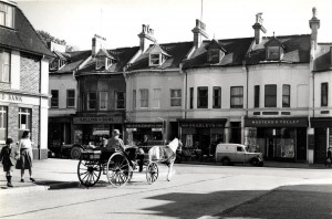
Hassocks 1951 – Junction of Grand Avenue and Keymer Road.
Photograph by Peter Brooks. West Sussex Record Office, PH 15092.
Reproduced by permission of the County Archivist
The railway also made Hassocks a handy destination for the pleasure-seekers of the Edwardian age who came to enjoy the tranquillity of the area.
With glorious views of the South Downs, Hassocks has clearly appealed to travellers and settlers down the centuries.
Today, Hassocks combines its character and quiet rural life with modern living, services and communications.


